All Children Can Be........... Cartographers!
- Christina Mesk

- Aug 16, 2020
- 8 min read
Updated: Dec 30, 2024
"I have an idea," I said to my ENL Co-Teacher, Amy Ziegner, "I think we should make topographic maps of Colombia instead of two-dimensional maps. I think we can make the maps out of salt dough. I've never made a salt dough map but I think we can learn."
Amy is an an amazing co-teacher and she is always willing to be my partner even when I have overly ambitious ideas. Amy immediately opened her laptop and started googling salt dough recipes and offered to meet with our literacy coach who had done a similar project with our morning intervention program for SIFE students. We were excited to use the maps to give students an opportunity to showcase their content knowledge of Colombia and give them a new venue to develop their language skills. Prior to beginning this project, our students had learned about the mountains that surrounded Bucaramanga and the landslides that engineers were trying to address at our Fulbright ETA's University. We had spent the first part of the school year collaborating with Rachel Shriver, a Fulbright ETA in Bucaramanga through Reach The World. We wanted to give the students a tactile experience so they could understand that landslides were as important to the people around Bucaramanga as flooding and sinkholes were to the residents of Sunset Park, Brooklyn.
That was the beginning of a 3-month classroom project. About halfway through this project, I looked up at Amy across the classroom and our eyes met. We both knew we had taken on way more than we had expected but we were determined to see this project through.
We had expected the maps to take a month to create but we quickly learned that eight, 45 minute periods were not going to be enough time for our students to finish their maps. As an educator, I do believe that quality is more important than quantity. Slowing down and really diving deep in a project is often more beneficial to students than jumping quickly from topic to topic. We were also addressing more than content with this map project. We were helping the students to practice many of the habits and "soft skills" that are so necessary to success in a 21st century work environment such as making a plan, setting & prioritizing goals, finding win-win solutions, listening to each other and collaborating. We were also incorporating the arts in a way that is not typical of most Social Studies instruction. Most Social Studies classrooms assess knowledge and skill through written exams. Engaging the students as cartographers allowed my students with disabilities and multi-language learners to demonstrate their content knowledge in a way that would not be evident on a written exam. Additionally, I know that the more senses we use to learn new content or new skills, the more likely we will be to retain it. Although, we had limitations on the amount of periods we could dedicate and we had to create specific scaffolding to support our students in a way that general education students might not have needed, we were determined to stick with our maps until the end.


Amy and I began this project by using images to explore different kinds of maps and the different ways cartographers can make maps. We created a tool to help our students make a plan for what they would like to include on their maps of Colombia. All groups had to include the Andes Mountains but the other landmarks were entirely up to each group. We wanted the students' voices and interests to take the lead within this project. After looking at their first attempt at planning, we realized that some of the students needed help being more specific about what they wanted to show and they needed help deciding where to put specific landmarks on the maps. Other students were being so imaginative, that they were adding geographic features that were not part of the Colombian terrain. We hadn't anticipated any of these roadblocks. We were sure that our students would be able to easily synthesize their knowledge of Colombia with mapmaking. Amy had created a picture dictionary that summarized much of the content we had acquired from Rachel, our Fulbright ETA, through her video calls, journals and field notes. We had also just finished creating a travel magazine about Colombia in which the students had already demonstrated they could synthesize this content.
In hindsight, I realize that these roadblocks were really connected to the limited time students in elementary school spend looking at maps and interpreting information on them. Most of my students do not even have a reason to pay attention to a GPS because they are usually with adults who are managing it. This makes me want to do more lessons with map reading and interpretation at the beginning of each school year that goes beyond identifying points on a compass rose and locating landmarks. I think it would be helpful to introduce geography through an inquiry study.
Amy and I decided to go forward with making the salt dough and to address these roadblocks afterwards. Making the salt dough was messy but probably the easiest portion of this project. My students have participated in Cookshop for many years and have a lot of experience cooking and baking with their families. The salt dough recipe was simple but some of the students made a dough that was either too dry or too wet. Through questioning, prior knowledge and critical thinking, the students were able to figure out how they could add more flour to a dough that was too wet or they could add more water to a dough that was too dry. The dough kept really well in sealed plastic bags and technically it did not have to be refrigerated. However, we did keep ours in a refrigerator out of an abundance of caution.
Before the students could begin building their maps, we showed the students how to use digital tools to locate specific landmarks they wanted to include. All students had to label a draft map on the back of their planning sheet. For the groups that wanted to add geographic features that were not truly present in Colombia, we asked them to use Google Earth and Nat Geo Map Maker to support their claims. We also held small group discussions about why it is important for maps to be accurate. At that point in time, I was scheduled to be teaching in Colombia in July 2020 and we told the students that I was going to use their maps when I went to Colombia so they had to be accurate. By giving the students an audience for their maps, it helped them to understand the importance of building accurate maps. As one student put it, "We don't want Ms Mesk to get lost in Colombia. She has to know where things really are." When it came to painting the maps and adding objects to represent landmarks, this problem did resurface, but we were always able to redirect the students by reminding them that I was going to use these maps in Colombia.
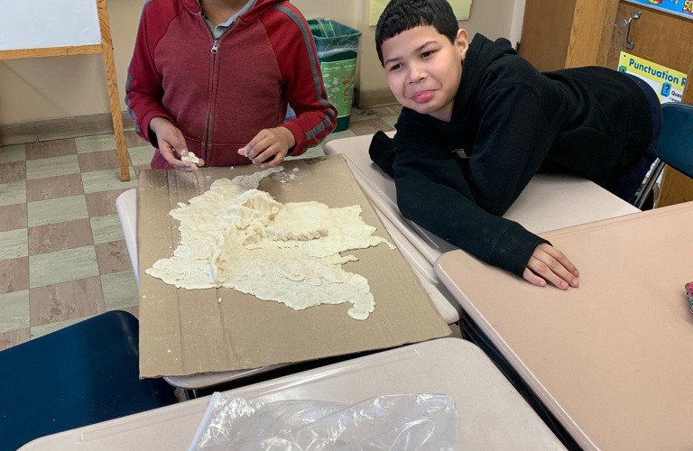
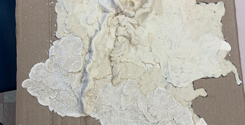
The students built the maps on their own. Amy and I gave each group an outline of Colombia on cardboard. We created that outline by taping the cardboard to the
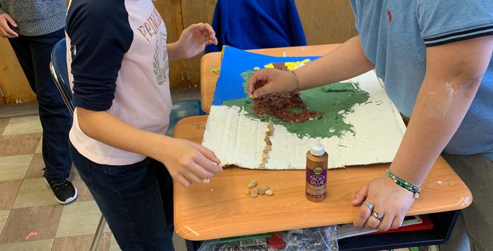
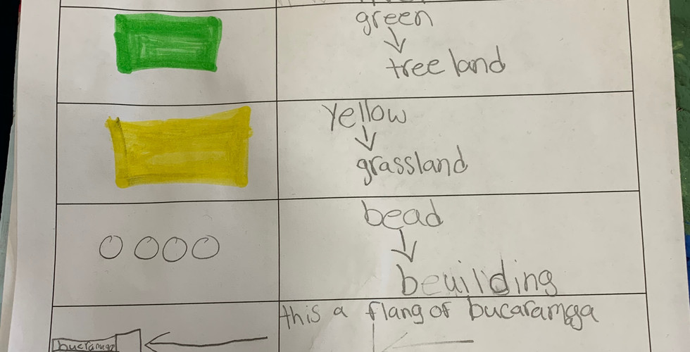
smartboard and projected an outline map of Colombia. We traced the projection onto the cardboard for each group. This is an activity students could have done but we were already behind on our anticipated timeline. We used videos to model two different techniques for building the maps and coached the groups as they were placing the dough on the cardboard. After the maps were built, we used other maps to discuss how cartographers use color to show information on a map. Students had to plan out what color each section of the map would be and what each color would be telling their readers. We also used the same techniques when adding landmarks. Students used a variety of objects to show their landmarks and they had to be able to explain what each object represented. The students were given a checklist/rubric to help each other stay on track. After painting and adding landmarks, the students created a mapkey.


This project was a labor of love for my students, Amy and I. In addition to coaching our students through cartographic skills, we found ourselves coaching them through the necessary "soft skills" they needed to complete this project such as making a plan, setting & prioritizing goals, finding win-win solutions, listening to each other and collaborating. Towards the end of this project, most of our coaching was on helping students to compromise with each other and to listen and speak to each other with empathy. Don't get me wrong, they weren't rude or unkind to each other. They just didn't understand that in order to work together you cannot assume the people around you implicitly know your intentions. I know many adults who still struggle to understand this. Because many of my students struggled with attention to task, we also had to frequently stop to discuss what it looks like when everyone is engaged in a task and strategies to keep everyone involved. Some of my more assertive students also had to learn that they had to release some of the responsibilities to other students in the group to show that everyone in the group was capable and valued. Some of my more retiring students had to learn that their wonderful ideas would not be appreciated unless they spoke up.
During those 3-months we learned so much more than geography. We learned that great things are possible and problems can be solved when human beings listen to each other, compromise and collaborate. We also learned that there is great joy in a productive struggle. Being cartographers was fun for my students even though the task was challenging! I had students who consistently asked if their Speech Providers and Counselors could push-in to the classroom so they did not miss out on mapmaking. For most of my students, this was their favorite part of the school day!


My greatest regret is that we were unable to showcase and celebrate these beautiful maps with the rest of our school community. We had plans to hold a museum walk through and to invite other classes to view our maps. Our maps were completed on March 13th. We didn't know then that would be our last day inside room 307. When we started remote instruction, I did have the students complete some writing pieces about their maps. I even added photos of the maps in each student's Google Doc but the enthusiasm for the maps was lost amongst the uncertainty and fear around the pandemic and the abrupt transition to remote learning. Most of the students completed an informational and persuasive writing piece about the maps but not to level of competency they would have displayed had they been able to sit next to their completed maps while they were writing.
I am so sad my students didn't get to share their hard work with the rest of our school community. I want my students to know that I am so proud of their effort and dedication. Amy and I did not give them an easy task but they still rose to the occasion regardless of the many roadblocks they faced.
Those maps are still in room 307. An art teacher recommended that I spray the maps down with Mod Podge so they last. However, I don't know what to expect when I go back to room 307 in a few weeks. Our custodians have been working hard to make sure our school is safe for students and teachers to return to the classroom. It is very possible the maps may no longer be in the best condition. Whatever condition they are in, they will be artifacts from a different era in collaborative learning. I know that it will be sometime before I can safely engage students in this type of collaborative makerspace and that makes me deeply sad. Safety and health will be our priority when we return to our school building. For the next little while in education, collaboration will have to happen through conversation and digital space. Arts and engineering will occur as independent tasks. Amy and I may have taken on a lot more than we expected to back in January but I am genuinely excited for a time when I can safely bring this type of learning back to my classroom.


Comments